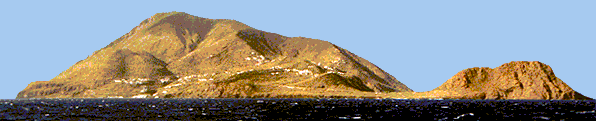
This is
Mount capo Graziano, in the south east portion of Filicudi. The
houses at the bottom of the picture are located in "La Guardia".
Upon it there's the beautiful neolithical village.
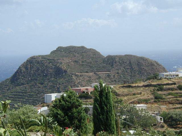
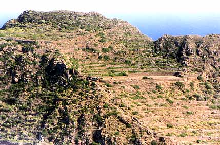
The very same place seen from Porto.
On the extreme left of that picture, at sea level, are located
the ancient "grinding mill stones"
carved by ancient inhabitants of Filicudi in the rock.
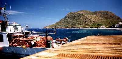
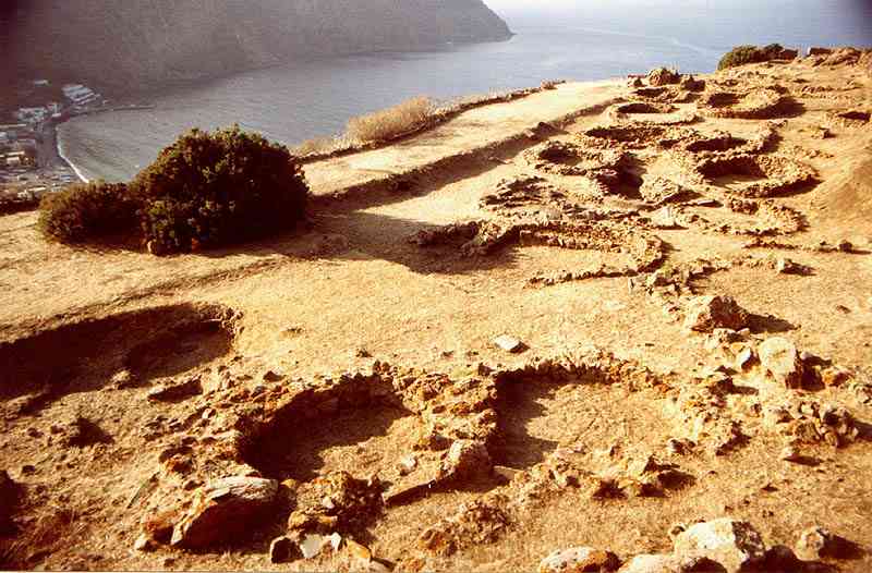
Here's the Neolithic village,
upon Mount Capo Graziano.
It's the subtle terrace you see in bright colors
in the mountain.
This pic is shot from Valle di Chiesa.
It takes about 10 minutes to climb up to the neolithic
village shown in the following picture..
About the neolithic village of Capo Graziano
Mount .
Like the other Aeolian islands, Filicudi
must have been home to groups of permanent inhabitants from the
Late Neolithic, around 3000 B.C.
At the beginning of the Bronze Age, perhaps even before the end
of the III millennium, a large settlement rose up on the island,
without doubt populated by newcomers from afar, who settled there
and whom we believe we may identify as the Aeolians of legend,
whose name the islands still carry.
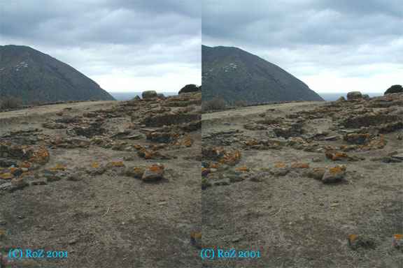
Picture: Neolithic Village
of Capo Graziano, in Filicudi, in Stereoscopic 3D format. How
to dive into this picture. Yes.. I know.. it is a great 3d
shot, thank you ;-)
This is one of the most extensive prehistoric
settlements of the Aeolian Islands (Piana
del Porto - Casa Lopez).
After some centuries, that is, at the beginning of the II millennium
B.C., the settlement moved up from the indefensible seashore ("Piana
del porto" near, capo
graziano beach) to the summit
of the mount of Capo Graziano (),
a rocky cupola with almost completely inaccessible slopes which
formed a veritable natural fortress: a much less hospitable position,
but one which could much more easily be defended.
Evidently this move was imposed by a change in the political situation
in the Lower Tyrhennian and by the emergence of serious preoccupations
with defence amongst the coastal populations.
(click
to enlarge this emage the image)
The excavations carried out between
1956 and 1969 were concentrated upon a large terrace on the western
flank of the mount, at a height of around 100 metres.
Here a little under thirty huts were brought to light, built very
close together in keeping with a large population and a limited
available space.
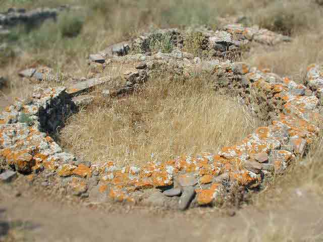
They are oval huts,
some with a "fishbone" structure following a Helladic
tradition which, along with the type of huts and the pottery forms,
would seem to correspond to the Protohelladic III of Greece.
Those "houses" had straw roofing.
Fragments of Protomycenaean
painted pottery of style I and II offer a very precise dating
element and allow us to perceive that the cultural facies of Capo
Graziano continued to evolve until the passage of the Mycenaean
II style to the Mycenaean III, that is, until around 1430 B.C.
(I know.. this seems too archeo-techy-stuff...sorry!)
Ove the levels of the culture of Capo Graziano are superimposed
those of the culture of Milazzese, characterised by quite different
pottery of Sicilian origin.
Numerous fragments of imported Aegean pottery are also found in
the huts of this new phase, but they are now in the Mycenaean
III A1 style, that is, belonging to the end of the XV and the
beginning of the XIV century B.C.
After the destruction of this last
village, which may be related to the Ausonian conquest of the
islands, the whole island of Filicudi appears to have remained
deserted for many centuries.
Filicudi
was inhabited once again in the Greek age (a few pottery fragments
of the VI - V century B.C. from Capo Graziano; small vases from
a tomb of the IV century from the Piano del Porto; an inscribed
gravestone in Lipari stone from Zucco Grande).
Remains of habitations from the Roman age are still recognisable
on the flat land above the beach on the northern side of the Piano
del Porto.
From the Christian-Byzantine age there is a group of tombs dug
out of the rock, without grave-goods, which came to light on the
ridge of the Piano del Porto during exploratory excavations in
1952.
Here's
a small map I made to show you where pre-historic men decided to
live in Filicudi.
Watch it closely... see... today abusive ( aka against the law)
building stand over the archeological sites...
One question I'm forced to ask... why
the hell there are so many houses over those archeological sites,
even if in Filicudi it is forbidden to build anything new since
dozens of years? How come authorities and citizens seem blind? The
is only one route in Filicudi, and everybody MUST pass in front
of buildings. In Filicudi quite every building material is taken
there by ferry... how come? Do you know the answer to my question?
;-) Will authorities try at least to arginate the phoenomenon? Will
people of Filicudi understand someday that protecting their own
land is the best way to obtain easy money from tourists?
 Filicudi
was inhabited once again in the Greek age (a few pottery fragments
of the VI - V century B.C. from Capo Graziano; small vases from
a tomb of the IV century from the Piano del Porto; an inscribed
gravestone in Lipari stone from Zucco Grande).
Filicudi
was inhabited once again in the Greek age (a few pottery fragments
of the VI - V century B.C. from Capo Graziano; small vases from
a tomb of the IV century from the Piano del Porto; an inscribed
gravestone in Lipari stone from Zucco Grande).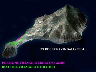 Here's
a small map I made to show you where pre-historic men decided to
live in Filicudi.
Here's
a small map I made to show you where pre-historic men decided to
live in Filicudi.